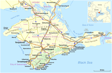
Crimea
Jump to navigation
Jump to search
peninsula in Ukraine | |||||
| Upload media | |||||
| Pronunciation audio | |||||
|---|---|---|---|---|---|
| Instance of | |||||
| Location |
| ||||
| Located in or next to body of water | |||||
| Significant event | |||||
| Highest point | |||||
| Population |
| ||||
| Area |
| ||||
| Different from | |||||
 | |||||
- Українська: Автономна Республіка Крим: де-юре — входить до складу України, де-факто — був окупований та анексований Росією у 2014 році. Розташована на Кримському півострові між 44°23’ – 46°15’ північної широти та 32°29’– 36°39’ східної довготи. Населення — 2,034 млн. осіб, площа — 26100 кв. км.
- Deutsch: Krim - ist eine Halbinsel im nördlichen Schwarzen Meer und autonome Republik innerhalb der Ukraine mit einer Fläche von 26.100 km² und rund 2,034 Millionen Einwohnern.
- Eesti: Krimm on Ukrainale kuuluv poolsaar Musta mere põhjaosas, mille on annekteerinud Venemaa.
- English: Crimea is a peninsula and an autonomous republic of Ukraine on the northern coast of the Black Sea. Is situated between 44°23’N – 46°15’N and 32°29’E – 36°39’E. Crimea's area is 26,100 square kilometres (10,100 sq mi) and its population was 2,033,700. In 2014 it was occupied and annexed by Russia.
- Français : La Crimée est une presqu'île située au sud de l'Ukraine, plongeant dans la mer Noire, constituant une république autonome.
- Galego: Crimea - é unha península e república autónoma de Ucraína.
- Polski: Krym - półwyspa i republika autonomiczna Ukrainy na północnym wybrzeżu Morza Czarnego.
- Русский: Крым — Автономная республика в составе независимой Украины, расположенная на Крымском полуострове между 44°23’ – 46°15’ северной широты и 32°29’ – 36°39’ восточной долготы. Имеет площадь 26100 км² и 2,034 миллионов жителей. Согласно российскому законодательству, входит в состав РФ.
- Türkçe: Kırım - Karadeniz'ın kuzeyinde yarımada. Kırım Tatarlarının anavatanı.
Views of Crimea | Symbols of Crimea | Crimean War | Maps of Crimea | Panoramic images
Views of Crimea[edit]
-
New bridge
-
Crimea
-
Crimea
-
Chersonesos Taurica (UNESCO)
-
Chersonesos Taurica (UNESCO)
-
English: The Livadia Palace near Yalta.Français : Palais de Livadia, près de Yalta, où fut signé le traité de Yalta en 1945.
-
English: Swallow's Nest, a neo-gothic romantic castle near Yalta.Français : Palais Nid d'hirondelle, près de Yalta.
-
English: The southern view of the Vorontsovkyi Castle in Alupka.
-
English: "Goddess of Night" fountain in Gurzuf.Русский: Фонтан «Богиня Ночь» в Гурзуфе.
-
English: Today's view of Balaklava - the Gulf of Balaklava.
-
English: Front side of the Massandra Palace in Massandra.Deutsch: Frontansicht des Massandra Palastes.
-
space
-
space
-
coast
-
Ai-Petri
-
Massandra
-
Panorama Building, Sevastopol
-
Sudak, The Genoese Fortress
-
Swallow's Nest
Coastline[edit]
-
Tarkhankut, Rocks in the sea
-
Atlesh rocky coastline
-
Djangul, Limestone rocks
-
Djangul
-
Ayu-Dag slopes, Gurzuf
-
Beach of Cape Fiolent
-
Black Sea, Fiolent
-
Cape Aya from Cape Fiolent
-
Cape Fiolent, Jurassic Rocks
-
Cape Fiolent, west side
-
Jurassic landscape with Karadag rocks by the sea
-
Karadag cliffs in the sea
-
Karadag cliffs
-
Popovka, Crimea, Black Sea
-
Mountains by the sea, Sudak
-
Bay of Novy Svet
-
Orestes and Pylades Cliffs by Cape Fiolent
-
Novy Svet
-
Rocks in the sea, Fiolent
-
Rock formations by the sea, Karadag
-
Sevastopol Bay
-
Sokol Rock
-
Fiolent
-
Aya Cape
-
Lisya Bay
-
Aya Cape
-
Aya Cape
-
Novy Svet
Symbols of Crimea[edit]
-
English: Flag of Crimea - is the official flag of the Republic of Crimea, Russia, as well as of the Autonomous Republic of Crimea, Ukraine.
-
English: Coat of arms of Crimea - is the official coat of arms of the Republic of Crimea, Russia, as well as of the Autonomous Republic of Crimea, Ukraine.
Crimean War[edit]
-
English: A map of the Crimean War from an atlas published in 1912.
-
Français : Battaglia di Balaclava, (1) Carica della brigata pesante, (2) Sottile linea rossa, (3) Carica della brigata leggera, (4) Carica degli Chasseurs d'Afrique.
-
English: Charge of the Light Brigade. Painting by Richard Caton Woodville (1825-1855).
-
English: The Thin Red Line, painted in 1881 by Robert Gibb. Painting showing the 93rd Sutherland Highlanders in battle with Russian cavalry at the Battle of Balaklava in 1854.
Maps of Crimea[edit]
-
English: Position of Crimea on the map of Ukraine.
-
Deutsch: Topographische Karte der Halbinsel Krim, Ukraine (in Englisch)English: Topographic map of the Crimea, Ukraine (in English).
-
Deutsch: Topographische Karte der Halbinsel Krim, Ukraine (in Deutsch)English: Topographic map of the Crimea, Ukraine (in German).
-
Deutsch: Physische Karte der Halbinsel Krim, Ukraine (in Englisch)English: Physical map of the Crimea, Ukraine (in English).
-
Deutsch: Physische Karte der Halbinsel Krim, Ukraine (in Deutsch)English: Physical map of the Crimea, Ukraine (in German).
-
Deutsch: Karte der Halbinsel Krim, Ukraine.
-
English: Geological map of Crimea, 1853
-
Deutsch: Karte der Halbinsel Krim / Quelle: Meyers Konversationslexikon von 1888, Band 10, Seite 223.
-
English: Administrative map of Crimea, excluding the city of Sevastopol.
-
satellite image
Seasons in Crimea[edit]
-
Demerdzhi in autumn
-
Demerdzhi in autumn
-
Demerdzhi in summer


_3.jpg/120px-Крымский_мост_(Росавтодор)_3.jpg)
_6.jpg/120px-Крымский_мост_(Росавтодор)_6.jpg)


.JPG/120px-Modern_Balaklava_-_Gulf_of_Balaklava_(16.07.2006_17-10-20).JPG)


_-_BL.jpg/120px-Geological_map_of_the_Crimea_-_Travels_in_Southern_Russia%2C_and_the_Crimea_(1853)_-_BL.jpg)


.jpg/1000px-Çufut_Qale_Panorama_(Klymenko).jpg)
.jpg/1000px-Ai-Petri_Mountain_(Klymenko).jpg)