File:Donbas (2015–2022).svg
.svg/800px-Donbas_(2015–2022).svg.png?20230924203154)
Original file (SVG file, nominally 1,523 × 1,005 pixels, file size: 2.08 MB)
Captions
Captions
Summary[edit]
| DescriptionDonbas (2015–2022).svg |
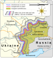
English: Map of the Donbas region of Ukraine, showing Russian separatist-controlled territory from the conclusion of the Battle of Debaltseve in 2015 to the outbreak of 2022 Russian invasion of Ukraine
institution QS:P195,Q16335075
institution QS:P195,Q605714
institution QS:P195,Q212
institution QS:P195,Q159 |
||||||||||||||||||||||||||||||||||||||||||||||||||||||||||||||||||||||||||
| Date | |||||||||||||||||||||||||||||||||||||||||||||||||||||||||||||||||||||||||||
| Source |
Own work based on: Information from:
|
||||||||||||||||||||||||||||||||||||||||||||||||||||||||||||||||||||||||||
| Author | Goran_tek-en | ||||||||||||||||||||||||||||||||||||||||||||||||||||||||||||||||||||||||||
| Permission (Reusing this file) |
This file is licensed under the Creative Commons Attribution-Share Alike 4.0 International license. Attribution: Goran_tek-en
|
||||||||||||||||||||||||||||||||||||||||||||||||||||||||||||||||||||||||||
| Other versions |
|
||||||||||||||||||||||||||||||||||||||||||||||||||||||||||||||||||||||||||
| SVG development InfoField | This vector image was created with Inkscape. |
||||||||||||||||||||||||||||||||||||||||||||||||||||||||||||||||||||||||||
| Object location | 49° 02′ 49.2″ N, 39° 05′ 34.8″ E | View this and other nearby images on: OpenStreetMap |
|---|
 | Please try to get in touch with the original author Goran tek-en of this file before uploading a new version. This file is based on original data, which contains essential additional information. Therefore it is preferable to make any changes based on the original data. Thank you! Alternatively, consider uploading your new version under a new name and tagging it as a derivative or extract of this file. {{subst:lle}} |
| This media should work for many people with some kind of color (blindness) deficiency. Due to the complexity of color deficiency, however, it may unfortunately not work for every one.
English ∙ Esperanto ∙ español ∙ Français ∙ македонски ∙ Svenska ∙ +/− |
File history
Click on a date/time to view the file as it appeared at that time.
| Date/Time | Thumbnail | Dimensions | User | Comment | |
|---|---|---|---|---|---|
| current | 20:31, 24 September 2023 | .svg/120px-Donbas_(2015–2022).svg.png?20230924203154) | 1,523 × 1,005 (2.08 MB) | Mzajac (talk | contribs) | Updated English spelling for w:en:Berdiansk |
| 20:57, 13 September 2022 | .svg/120px-Donbas_(2015–2022).svg.png) | 1,523 × 1,005 (2.08 MB) | Batouki (talk | contribs) | File uploaded using svgtranslate tool (https://svgtranslate.toolforge.org/). Added translation for en. | |
| 22:14, 10 September 2022 | .svg/120px-Donbas_(2015–2022).svg.png) | 1,523 × 1,005 (2.07 MB) | Batouki (talk | contribs) | File uploaded using svgtranslate tool (https://svgtranslate.toolforge.org/). Added translation for fr. | |
| 18:30, 9 September 2022 | .svg/120px-Donbas_(2015–2022).svg.png) | 1,523 × 1,005 (2.07 MB) | Batouki (talk | contribs) | File uploaded using svgtranslate tool (https://svgtranslate.toolforge.org/). Added translation for fr. | |
| 16:14, 10 March 2022 | .svg/120px-Donbas_(2015–2022).svg.png) | 1,523 × 1,005 (2.03 MB) | Goran tek-en (talk | contribs) | minor stuff | |
| 10:54, 10 March 2022 | .svg/120px-Donbas_(2015–2022).svg.png) | 1,518 × 1,000 (2.03 MB) | Goran tek-en (talk | contribs) | Donbas text edited requested by RGloucester | |
| 17:31, 9 March 2022 | .svg/120px-Donbas_(2015–2022).svg.png) | 1,518 × 1,000 (2.03 MB) | Goran tek-en (talk | contribs) | {{Information |description ={{en|Map of the Donbas region of Ukraine, showing Russian separatist-controlled territory from the signing of the Minsk II agreement in 2015 to the outbreak of 2022 Russian invasion of Ukraine}} {{Institution |wikidata=Q16335075}} {{Institution |wikidata=Q605714}} {{Institution |wikidata=Q212}} {{Institution |wikidata=Q159}} |date =2022-03-09 |source ={{Own}} <br> Derived from; *[https://www.openstreetmap.org/#map=7/49.432/37.595 OSM] In... |
You cannot overwrite this file.
File usage on Commons
The following 5 pages use this file:
File usage on other wikis
The following other wikis use this file:
- Usage on azb.wikipedia.org
- Usage on be.wikipedia.org
- Usage on bs.wikipedia.org
- Usage on de.wikipedia.org
- Usage on en.wikipedia.org
- Usage on en.wikinews.org
- Usage on fr.wikipedia.org
- Usage on he.wikipedia.org
- Usage on hr.wikipedia.org
- Usage on ko.wikipedia.org
- Usage on nl.wikipedia.org
- Usage on sl.wikipedia.org
- Usage on tr.wikipedia.org
- Usage on uz.wikipedia.org
Metadata
This file contains additional information such as Exif metadata which may have been added by the digital camera, scanner, or software program used to create or digitize it. If the file has been modified from its original state, some details such as the timestamp may not fully reflect those of the original file. The timestamp is only as accurate as the clock in the camera, and it may be completely wrong.
| Width | 1523.4 |
|---|---|
| Height | 1005 |


