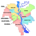
File:Kiev map english.png

Original file (3,990 × 3,978 pixels, file size: 11.87 MB, MIME type: image/png)
Captions
Captions
Summary[edit]
Licensing[edit]

|
Permission is granted to copy, distribute and/or modify this document under the terms of the GNU Free Documentation License, Version 1.2 or any later version published by the Free Software Foundation; with no Invariant Sections, no Front-Cover Texts, and no Back-Cover Texts. A copy of the license is included in the section entitled GNU Free Documentation License.http://www.gnu.org/copyleft/fdl.htmlGFDLGNU Free Documentation Licensetruetrue |
If this file is eligible for relicensing, it may also be used under the Creative Commons Attribution-ShareAlike 3.0 license. The relicensing status of this image has not yet been reviewed. You can help. العربية ∙ azərbaycanca ∙ беларуская (тарашкевіца) ∙ български ∙ বাংলা ∙ català ∙ čeština ∙ Deutsch ∙ Deutsch (Sie-Form) ∙ English ∙ español ∙ eesti ∙ فارسی ∙ suomi ∙ français ∙ galego ∙ עברית ∙ hrvatski ∙ magyar ∙ italiano ∙ 日本語 ∙ 한국어 ∙ lietuvių ∙ македонски ∙ മലയാളം ∙ Bahasa Melayu ∙ Nederlands ∙ occitan ∙ português ∙ português do Brasil ∙ română ∙ русский ∙ sicilianu ∙ slovenščina ∙ српски / srpski ∙ svenska ∙ Türkçe ∙ ไทย ∙ українська ∙ Tiếng Việt ∙ 简体中文 ∙ 繁體中文 ∙ +/− |
Original upload log[edit]
- 2005-12-28 19:59 Mno 665×663× (134079 bytes) Map of Kiev separated into raions, with Dnipro and Desna rivers, labelled in Englush. Small corrections to river in the south, single-color transparency. Author: [[User:mno ]]- me.
- 2005-12-28 19:36 Mno 667×663× (124742 bytes) Map of Kiev separated into raions, with Dnipro and Desna rivers, labelled in Englush. Author: [[User:mno]] - me.
File history
Click on a date/time to view the file as it appeared at that time.
| Date/Time | Thumbnail | Dimensions | User | Comment | |
|---|---|---|---|---|---|
| current | 22:12, 3 March 2022 |  | 3,990 × 3,978 (11.87 MB) | OgreBot (talk | contribs) | (BOT): Reverting to most recent version before archival |
| 22:12, 3 March 2022 |  | 667 × 663 (122 KB) | OgreBot (talk | contribs) | (BOT): Uploading old version of file from en.wikipedia; originally uploaded on 2005-12-28 19:36:08 by Mno | |
| 04:19, 18 September 2021 |  | 3,990 × 3,978 (11.87 MB) | Athosmera (talk | contribs) | AI upscale | |
| 16:26, 4 September 2006 |  | 665 × 663 (103 KB) | D0ktorz (talk | contribs) | smaller | |
| 20:50, 2 September 2006 |  | 665 × 663 (131 KB) | DDima (talk | contribs) | Map of Kiev separated into raions, with Dnipro and Desna rivers, labelled in English. Author: User:mno - me. {{GFDL-self}} Category:Maps of Kiev |
You cannot overwrite this file.
File usage on Commons
The following 6 pages use this file:
File usage on other wikis
The following other wikis use this file:
- Usage on be.wikipedia.org
- Usage on ca.wikipedia.org
- Usage on cs.wikipedia.org
- Usage on cv.wikipedia.org
- Usage on de.wikipedia.org
- Usage on en.wikipedia.org
- Usage on en.wikivoyage.org
- Usage on es.wikipedia.org
- Usage on fi.wikipedia.org
- Usage on fr.wikipedia.org
View more global usage of this file.

.svg/150px-Kyiv_map_(en).svg.png)